

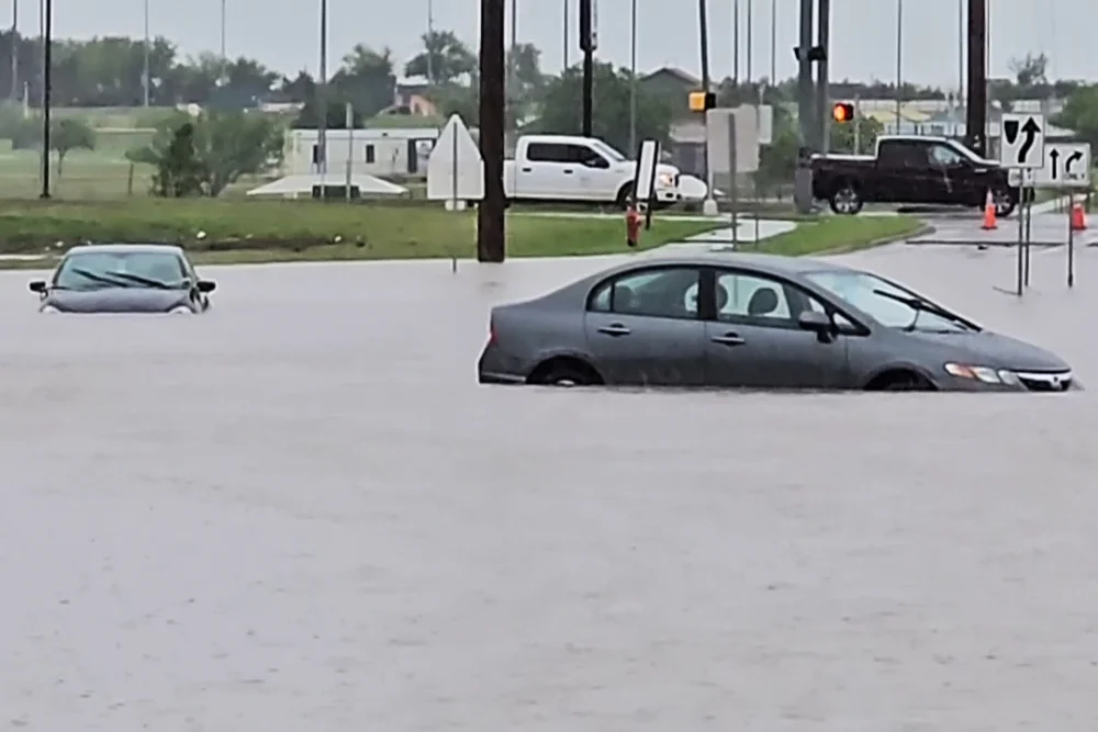
At least one person has died in southwest Oklahoma after flash flooding impacted the region, with authorities urging residents to stay off the roads as severe weather warnings remain in effect.
The Lawton Police Department reported that emergency responders witnessed a vehicle driving into standing water earlier in the day. Unfortunately, they were unable to safely reach the submerged vehicle.
An investigation into the death is underway, with officials confirming that the dive team assisted in recovering the victim. The family has been notified, but the victim’s identity has not been disclosed.
Oklahoma Governor Kevin Stitt expressed appreciation for the first responders who performed water rescues throughout the day. He also urged Oklahomans to be cautious. “Thank you to our wonderful first responders who’ve been executing water rescues all day due to flooding from heavy rain,” he wrote on X. “Oklahomans, be extra careful when driving and don’t try to drive through flooded roads. Stay weather aware!” By Sunday afternoon, Lawton city officials reported that water levels had started to recede in some areas.
Further south, in Walters, Oklahoma, Cotton County Emergency Management issued a public notice advising residents to evacuate flood-prone areas. Floodwaters were expected to continue rising through the afternoon, and emergency management is working to provide additional sand and sandbags for residents.
Elsewhere in the Southwest and Rockies, extremely critical fire weather conditions persisted Sunday afternoon due to 60 mph wind gusts, low humidity, and dry vegetation. About 7 million people across Colorado, Arizona, New Mexico, and western Texas are under alert. Additional severe weather threats, including high winds, large hail, and potentially tornadoes, extend from Montana to Texas, with storms expected to last into Sunday night.
On Monday, 36 million people from Texas to Michigan will be in the path of severe weather, impacting major cities like Minneapolis, Chicago, and Oklahoma City.
The most intense storms are expected late in the afternoon and into the night, with the possibility of strong tornadoes, large hail, and powerful wind gusts. Localized flash flooding may also affect parts of the central U.S.
By Tuesday, the risk will shift northward toward New York, affecting 37 million people under a slight risk of severe weather, including areas like Indianapolis, Oklahoma City, and Cleveland. As the system moves east, scattered thunderstorms with strong winds, hail, and isolated tornadoes are possible.
As the week progresses, parts of the upper Midwest will face a moderate risk of severe weather.